Meteonorm is updated with new climate, current and future data
Eight years after launching version 7, Meteotest publishes Meteonorm version 8. The upgrade includes mainly new and more current climate periods, better access to ongoing timeseries and updates of the software. The user interface of the desktop software hasn’t been changed much.
With the publishing of version 8 support for Meteonorm version 6 (2006) is no longer available.
The prices of the desktop software stay the same. We still offer discounts for multiple licenses, users of version 7 and for educational purposes.
What’s new?
Compared to version 7.3, Meteonorm version 8 is based on more recent data from the following periods:
- 1996 – 2015: new main period for radiation parameters
- 2000 – 2019: new main period for temperature, dew point temperature, wind, precipitation and days with precipitation
This recent time period is denoted in the new Version as “contemporary”. It is still possible to choose a “historic” data period (1981 – 1990 for radiation and 1961 – 1990 for temperature).
- Access to ongoing current time series based on satellite (Europe, Africa, Near East) and Re-Analysis data (ERA-5T, rest of the world)
- New satellite data based on an own, globally homogeneous satellite model, including satellite data for Asia and the Americas
- Future data for IPCC Scenarios RCP 2.4, 4.5 and 8.5 from 10 global climate models based on CMIP5 are included (2020 – 2100)
- Detailed model for urban effects based on the H2020 climate-fit.city project. 100 cities in Europe include urban effects for the contemporary climates. Barcelona, Berlin, Bern, Bremen, Prague, Rome and Vienna additionally include urban effects of 2050 for two scenarios.
- Current data (downloaded timeseries) include the new parameters Td, FF, DD and RR (previously only Ta and Gh)
- The software was partly refactored, updated and bugs fixed. Climate data are mostly stored as .png files to achieve maximum compression rates.
- Clearer structure and separation of climate and/or imported / current data
New radiation maps
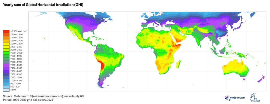
The global radiation maps have been updated. They are now based to a greater extent on satellite data.